

An increase in sea level as a result of global warming, according to data, poses a threat to millions of coastal dwellers across the world. Some states in India which have been witnessing rapid coastal erosion such as Gujarat, Tamil Nadu and West Bengal face greater risk due to this rise in sea level.
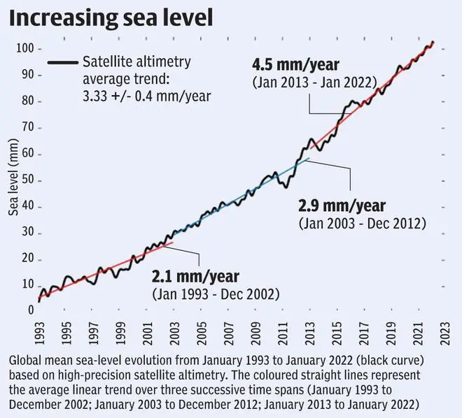
The Global Mean Sea Level (GMSL) reached a new record high in 2021, increasing at an average 4.5 mm per year over the period 2013 -2021. This is more than double the rate at which sea levels rose between 1993 and 2002. Rise in sea level is substantially faster than the global mean in the South-west Indian Ocean according to data presented in the State of Global Climate–2021 report by the World Metrological Organization, released last month.
GMSL integrates changes occurring in many components of the climate system. On inter-annual to multi-decadal time scales, changes to GMSL result from ocean warming via thermal expansion of seawater, melting of land ice and exchange of water with water bodies on land.
“Measured since the early 1990s by high-precision altimeter satellites, the GMSL rose by 2.1 mm per year between 1993 and 2002, and by 4.5 mm per year between 2013 and 2021, an increase of 2,4 mm between the periods, attributed mostly to the accelerated loss of ice mass from ice sheets,” stated the report.
The report also added thatas compared with previous El Niño and La Niña years (for example, in 1997/1998, 2010/2011, 2015/2016), during which the GMSL displayed temporary positive or negative anomalies of several millimetres, 2021 was marked by an increase of the GMSL that was close to the long-term trend.
Rise not uniform
The report adds that although the sea level has risen almost everywhere since 1993, it has not risen equally everywhere. Several regions continue to be affected by a rate of sea-level rise substantially faster than the global mean which shows the difference between local and global sea levels. This is particularly the case in the western Tropical Pacific, the South-west Pacific, the North Pacific, the South-west Indian Ocean and the South Atlantic.
Affect on Indian coasts scenario
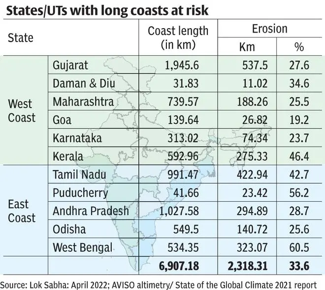
The Ministry of Earth Sciences told Lok Sabha last month that the National Centre for Coastal Research (NCCR), Chennai is monitoring shoreline erosion since 1990 using remote sensing data and GIS mapping techniques. The approximately 6,907.18 km long Indian coastline of the mainland has been inspected from 1990 to 2018, and it has been noted that about 34 per cent of the coastline is facing erosion in varying degrees . West Bengal has reported the highest 60.5 per cent erosion followed by Puducherry (56.2 per cent).
The XVth Finance Commission has suggested that the National Disaster Management Authority and or Ministry of Home Affairs develop suitable norms as mitigation measures to prevent erosion, and that the Union and States develop a policy to deal with the extensive displacement of people due to coastal and river erosion.
“At present, NDMA is in the process of drafting suitable norms for mitigation measures and is developing a policy to deal with the extensive displacement of people,” the Ministry informed Lok Sabha.
![]() Comments
Comments


Comments
Comments have to be in English, and in full sentences. They cannot be abusive or personal. Please abide by our community guidelines for posting your comments.
We have migrated to a new commenting platform. If you are already a registered user of TheHindu Businessline and logged in, you may continue to engage with our articles. If you do not have an account please register and login to post comments. Users can access their older comments by logging into their accounts on Vuukle.