
 across parts of central India and less heavy over adjoining parts of west and east-central India.")
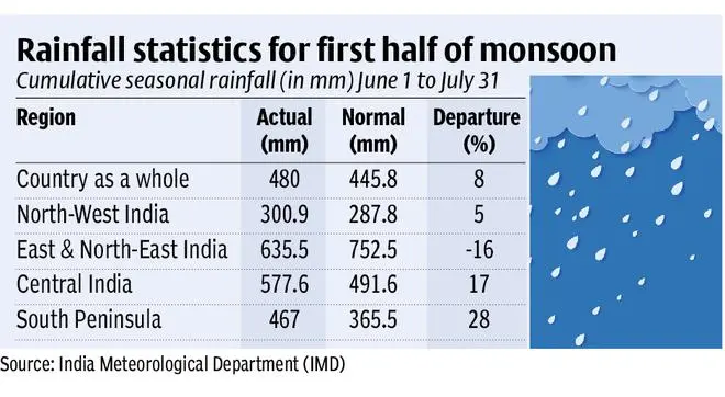
As the 2022 monsoon crosses the halfway mark, a quick glance back is enough to realise it may not have done a bad job in June (-8 per cent of the long-period average of rainfall, LPA) while July (+17 per cent of LPA) lived up to its name as the rainiest of the four monsoon months. This is not to ignore the obvious blips in east and north-east India and adjoining parts of north-west India (Uttar Pradesh et al) during this period, which is in line with the known monsoon pattern in which no single season ensures the uniform spread of rain across time and space (temporal and spatial).
A persistent rain deficit in the rice-growing region has tested the resolve of farmers and weather watchers alike. Relief brought by the rain-driving monsoon trough when slotting itself into position has not been enough to assuage building moisture stress here. Deficient or late arrival of rain has upset the kharif sowing schedule, apart from draining out some of the surplus received over parts of the country during both June and July. The surplus for the country as a whole has since been cut down to 8 per cent as on July 31 from two-digit figures earlier.
Rainiest July since 2005
Private forecaster Skymet Weather said this monsoon saw the rainiest July since 2005 (surplus of 17 per cent). It narrowly missed the quarter-century record of 333.7 mm rainfall in July 2005. This July also joined the club of rainiest months with over 300 mm rainfall recorded on four earlier occasions since 1995. At the midway mark, the meteorological subdivisions of West Rajasthan, Tamil Nadu and Telangana have recorded large excess of 81 per cent, 82 per cent and 94 per cent respectively. The vulnerable Gujarat, Marathwada and Vidarbha too found their way into the rainfall-positive category. The agriculture bowl of Punjab and Haryana also recorded big margins in excess of 20 per cent.
Union Minister Jitendra Singh told the Lok Sabha on July 26 that the monsoon rainfall has been normal during June for the country as a whole. The Long Period Average (LPA) of the rainfall for the month of June being 165.4 mm based on the data of 1971-2020. The rainfall is said to be normal if it is within 92-108 per cent of the LPA. The early onset of the monsoon on May 29 was part of a trend observed in the inter-annual variability of monsoon behaviour, the Minister said.
Decreasing rainfall trend
Quoting India Meteorological Department (IMD), he told the House that the Uttar Pradesh, Bihar, West Bengal, Meghalaya and Nagaland have shown significant decreasing trends in the monsoon rainfall during the recent 30 years period from 1989 to 2018. The annual rainfall over these five States along with Arunachal Pradesh and Himachal Pradesh also show significant decreasing trends. Other States do not show any significant changes in monsoon rainfall during the same period.
It is in this context that the rainfall trend for the second half of the monsoon (August and September) has come out. In its updated outlook issued on Monday, the IMD indicated rainfall over the country as a whole for August to September to be most likely normal (94-106 per cent of LPA). Region-wise, it would be normal to above normal rainfall for most parts of South India except the West Coast, west-central India and north-west India. It will be below normal for many parts of the West Coast and some parts of east-central, east and north-east India.
Outlook for August-September
Rainfall for August is expected to be normal (94-106 per cent of the LPA) for the country as a whole. It will be normal to above normal rainfall over most parts of south-east India, north-west India and adjoining west-central India and below normal along the West Coast and many parts of east-central, east and north-east India. The UK Met Office has indicated shortages for Vidarbha, Chhattisgarh, Odisha and West Bengal during August-September-October. The European Centre for Medium-Range Weather Forecasts sees normal to above normal rainfall for Peninsular India until mid-August.
‘May not be as productive’
GP Sharma, President, Meteorology and Climate Change, Skymet Weather, said the private forecaster sticks to its earlier projections that the second half of the monsoon may not be as productive as the first. “If you analyse the rainfall amounts during the last few days of July and into August, the reducing trend is evident. If this has to be reversed, we must have eight to nine mm of rain averaged for the country during the rest of August. This is a fair amount of rainfall, which needs back-up from the Bay of Bengal-based systems,” Sharma told BusinessLine. In this context, the behaviour of a couple of systems likely emerging in the Bay will be closely watched, he said.
East India may stay in red
August, according to Skymet projections, is likely to end with a rainfall deficit of 5 per cent, but that in itself is not alarming. “What is, is the spatial and temporal spread of rainfall. We don’t expect much purchase for the East and North-East since emerging systems may look the other way and speed away into central, west and north-west India. Even assuming that these systems stay anchored locally to make good the deficit by 5-10 per cent, it will not materially change the situation on the ground in the region,” Sharma said. The 94-106 outlook given by the IMD swings wildly from one end to the other. Already, its rainfall projections in this range for July have been surpassed by a wide margin (17 per cent surplus).
Global model projections
The US National Centres for Environmental Prediction concurs with the view that east and north-east India will continue to fall out of favour of the monsoon during this period. The South Korean APEC Climate Centre and the Application Laboratory of Japanese national forecaster Jamstec indicate rainfall deficit for eastern parts of Central India, east India and north-east India during August. As for September, the IMD says it will come out with a forecast on August 31. Early forecasts from a few global models signal normal to above normal rainfall for the country as a whole, including an improved outlook for east and north-east India during the month.
La Nina-IOD ensemble
Enabling large-scale conditions include a persisting but friendly La Nina in the Equatorial Pacific wherein waters close to the Asian continent (West Pacific) warms up promoting moisture build, convection, rain and storminess. A twin phenomenon closer home will see the West Indian Ocean cool down (negative Indian Ocean Dipole), which normally does not augur well for the monsoon. The net impact is reflected in the flooding rains over central India juxtaposed with dry conditions over east and north-east India. Global models indicate these conditions may gradually change for the better in August and September.
![]() Comments
Comments


Comments
Comments have to be in English, and in full sentences. They cannot be abusive or personal. Please abide by our community guidelines for posting your comments.
We have migrated to a new commenting platform. If you are already a registered user of TheHindu Businessline and logged in, you may continue to engage with our articles. If you do not have an account please register and login to post comments. Users can access their older comments by logging into their accounts on Vuukle.