India Meteorological Department (IMD) has predicted fairly widespread to widespread light to moderate rainfall with isolated heavy falls, thunderstorms, and lightning over the vulnerable Uttarakhand and West Uttar Pradesh until Saturday and East Uttar Pradesh until Sunday.
Isolated very heavy rainfall is likely over Uttarakhand and Uttar Pradesh today (Thursday) and Saturday. Isolated extremely heavy falls are likely over Uttarakhand and North-West Uttar Pradesh on Friday.
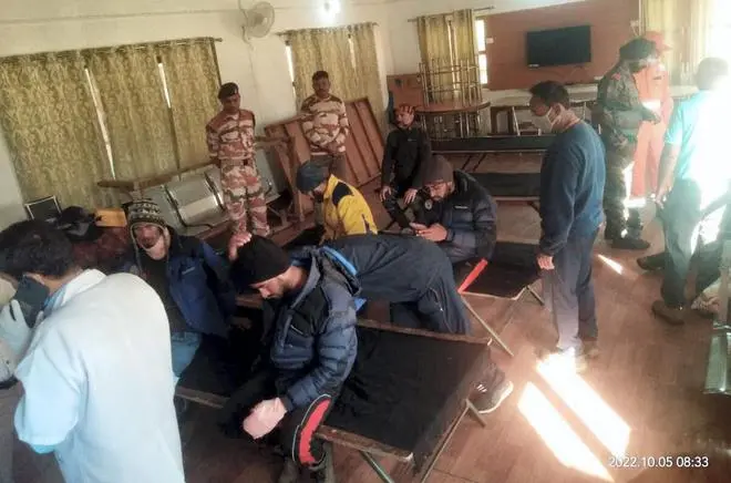
This forecast comes a day after 10 mountaineers were killed and 27 others went missing as a massive avalanche barreled into a group of the Uttarkashi-based Nehru Institute of Mountaineering (NIM) and trapped several others. A 41-member group from NIM, including 34 trainees and seven instructors, was hit by the avalanche around 8.45 am on Tuesday.

The first group of trainees, who were trapped in an avalanche in Draupadi’s Danda-2 mountain peak on Tuesday, take rest after their evacuation, at ITBP Matli Hospital in Uttarkashi district. (PTI)
Widespread rain in South
Towards the South, fairly widespread to widespread light to moderate rainfall with isolated heavy falls, thunderstorms and lightning is likely over Tamil Nadu until Sunday; over Coastal Andhra Pradesh and Yanam from today to Monday; Rayalaseema, on Friday and Saturday; Telangana, today (Thursday); and Interior Karnataka on Sunday.
Isolated very heavy rainfall is likely over Tamil Nadu, Puducherry and Karaikal today. Over North-East India, fairly widespread to widespread light to moderate rainfall with isolated heavy falls, thunderstorms and lightning is likely over Arunachal Pradesh, Assam and Meghalaya on Saturday and Sunday; and over Nagaland, Manipur, Mizoram and Tripura on Saturday, Sunday and Monday.
Monsoon withdrawal process
The monsoon withdrawal process may resume in the next 10 days, as per the numerical model predictions from the IMD, after Wednesday’s low-pressure area over Coastal Andhra Pradesh weakened into a cyclonic circulation today, though leaving behind a successor brewing in the Bay of Bengal.
As expected, the cyclonic circulation over Coastal Andhra Pradesh has cut open a trough northwards into Central India and adjoining North-West India. To the weatherman’s surprise, it has thrown open another trough from the tail and backward, reaching the South Bay where a successor cyclonic circulation is taking shape.
Cyclonic circulations
The latter may move into the Chennai-South Andhra Pradesh coast in the next two-three days bringing more rain to the region. It will later wriggle its way towards Mumbai coast and adjoining West Madhya Pradesh and onwards into Delhi and Uttar Pradesh before starting to weaken from October 14 under the onslaught of dry north-westerly winds from the withdrawing monsoon.
The withdrawal process has to stabilise and the seasonal anticyclone (high-pressure area and dry air) to establish over North-West India before the North-East monsoon can set in over the South Peninsula. This is not expected to happen at least by October 15, when forecasts are available.
This monsoon transition period (from South-West to North-East), replete with the presence of the odd cyclonic circulation, can trigger random thunderstorms and moderate to heavy rain over many parts of the country.
Dense clouds over AP, Telangana
Satellite pictures on Thursday morning showed thunderstorms leaving Chennai towards parts of North, Central and West Tamil Nadu from Puducherry, Salem, Coimbatore, Tiruchirappalli, Nagapattinam, Tondi and Madurai; and Kozhikode in Kerala.
Denser clouds had spread out over Nellore, Proddatur, Kurnool, Mahbub Nagar, Bellari, Manvi and Kalburagi across Andhra Pradesh, Telangana and North Karnataka.
Some clouds had sailed as far towards as Shegaon and Khandwa in Maharashtra and Madhya Pradesh. Dense clouds were also seen over Srikakulam, Rayagada, Brahmapur, Bhawanipatna and Bhubaneswar in Andhra Pradesh and Odisha.
The IMD has forecast fairly widespread to widespread light to moderate rainfall with isolated heavy falls over Odisha today; hills of West Bengal and Sikkim on Saturday and Sunday; East Madhya Pradesh today and tomorrow (Thursday and Friday); and West Madhya Pradesh from today to Saturday.


Comments
Comments have to be in English, and in full sentences. They cannot be abusive or personal. Please abide by our community guidelines for posting your comments.
We have migrated to a new commenting platform. If you are already a registered user of TheHindu Businessline and logged in, you may continue to engage with our articles. If you do not have an account please register and login to post comments. Users can access their older comments by logging into their accounts on Vuukle.