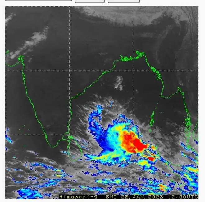
The months of January and February fall generally within a ‘silent period’ identified with the Bay of Bengal and the Arabian Sea. But not this year, if the noise building to the South-East of Sri Lanka is any indication. A low-pressure area in the area is gradually earning its spurs to grow in strength as a rare depression, as per the latest update from India Meteorological Department (IMD).
The parent low-pressure lay over South-East Bay of Bengal and the adjoining East Equatorial Indian Ocean on Saturday morning. It is likely to move gradually West-North-West and become ‘well-marked’ by Sunday in the first round of intensification. It will track in the same direction later and intensify further into a depression by Monday to reach near Sri Lanka coast the next day.

Thunderclouds around the low-pressure area over South-West Bay of Bengal captured by Japanese Himawari satellite in this screen grab | Photo Credit: V Karthik
Squally weather warned
The IMD has warned fishermen of squally weather over the South-East Bay wind speeds reaching 40-45 kmph gusting to 55 kmph and over South-West and adjoining South-West Bay on Sunday and Monday. Winds are expected to gather speed further to 45-55 kmph gusting to 65 kmph over South-West and adjoining South-East Bay on Tuesday while being at 40-45 kmph gusting to 55 kmph over the South-west Bay and along and off the Sri Lanka coast.
Gulf of Mannar, Comorin
On Wednesday (February 1), squally winds with speeds reaching 40-45 gusting 55 kmph are likely over the South-West Bay and along the North Sri Lanka and South Tamil Nadu coast. Wind speeds are expected to be higher at 45-55 kmph gusting to 65 kmph over Sri Lanka, the South-West Bay and the Gulf of Mannar and Comorin area on the same day. Wind speeds will remain at 40-45 gusting 55 kmph over the South-West and adjoining South-East Bay.

Rain clouds around the low-pressure area as depicted in the Pflotsch-ECMWF model | Photo Credit: V Karthik
Western disturbance on way
Over land, the IMD has predicted thunderstorms accompanied by lightning at isolated places over Tamil Nadu, Puducherry, Karaikal, Kerala and Mahe on Tuesday. On Wednesday too, a similar weather pattern will play out over South Tamil Nadu, South Kerala and Lakshadweep.
Meanwhile, another large western disturbance is on its way in and has reached East Iran and will take its time to cross in from the international border across Rajasthan and North-West India. Like the predecessor’s intense disturbance, it will feature high moisture feed as it likely spawns a secondary cyclonic circulation and dips over the Arabian Sea on Sunday and Monday.
Rain, snow for North-West
It will trigger light to moderate fairly widespread to widespread rainfall or snowfall over the hills of North-West India (Western Himalayan Region) and light to moderate scattered to fairly widespread rainfall over Punjab, Haryana, Chandigarh and West Uttar Pradesh on these two days. It will be light to moderate isolated to scattered rainfall over East Uttar Pradesh; over Rajasthan on Saturday and Sunday; and isolated light over Delhi on Sunday.
Isolated heavy rainfall or snowfall is forecast over the hills on Sunday and Monday. Isolated hail storms are likely over Himachal Pradesh, Uttarakhand, Punjab, Haryana and West Uttar Pradesh on these days; over East Rajasthan on Saturday and Sunday; and West Rajasthan on Sunday. Strong surface winds speeding to 20-30 of kmph may prevail over the plains on Sunday and Monday.


Comments
Comments have to be in English, and in full sentences. They cannot be abusive or personal. Please abide by our community guidelines for posting your comments.
We have migrated to a new commenting platform. If you are already a registered user of TheHindu Businessline and logged in, you may continue to engage with our articles. If you do not have an account please register and login to post comments. Users can access their older comments by logging into their accounts on Vuukle.