Travails of monsoon-flooded cities such as Bengaluru and Kochi (only a few days ago) may continue with India Meteorological Department (IMD) predicting continued fairly widespread to widespread rainfall with isolated heavy falls, thunderstorms, and lightning over South Interior Karnataka and Kerala for five more days.
A similar forecast is valid also for Telangana; for Coastal Andhra Pradesh on Thursday and Friday; Tamil Nadu and Puducherry up to Thursday; Rayalaseema from Tuesday to Friday; North Interior Karnataka on Tuesday, Thursday, and Friday; and Lakshadweep until Wednesday and later on Thursday, the IMD said.
Low-pressure area soon
This is in view of the possibility of a cyclonic circulation likely forming over the East-Central Bay of Bengal by Wednesday. It will eventually set up a low-pressure area (as already mentioned in these columns earlier) over the West-Central Bay of Bengal off the Andhra Pradesh-Odisha coasts two days later.

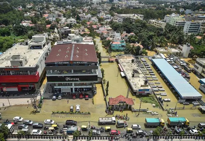
An aerial view of flooded Rainbow Drive Layout after heavy monsoon rains at Sarjapur, in Bengaluru, Monday, September 5, 2022. (PTI)
Numerical model projections by the IMD continue to suggest the formation of a second low-pressure area close on its heels, with both expected to intensify to at least depression strength.
Rain-friendly features
Already on Monday, the IMD signaled the eastern end of the monsoon trough currently over the plains of North India will shift to the South by Wednesday to dip into the Bay to make for a highway for the incoming ‘low’ to travel across Central India across Andhra Pradesh, Chhattisgarh, Madhya Pradesh, and Gujarat/Rajasthan.
This will propagate a regime of heavy to very heavy monsoon rain over this swathe, after a break. Also on view on Monday was a rain-friendly North-South trough running down from North Interior Karnataka to Comorin, tipped off by a cyclonic circulation over the Comorin and adjoining Maldives, which is currently pumping rain into South Peninsular India.
Heavy rain for Lakshadweep
The IMD said isolated very heavy rainfall is likely over Lakshadweep on Monday; over Tamil Nadu, Puducherry, and Karaikal on Tuesday and Wednesday; Kerala from Tuesday to Thursday; South Interior Karnataka (including Bengaluru) on Wednesday and Thursday; Coastal Karnataka on Thursday; and Coastal Andhra Pradesh and Telangana on Friday. Isolated extremely heavy rainfall is also likely over Kerala on Tuesday and Wednesday.

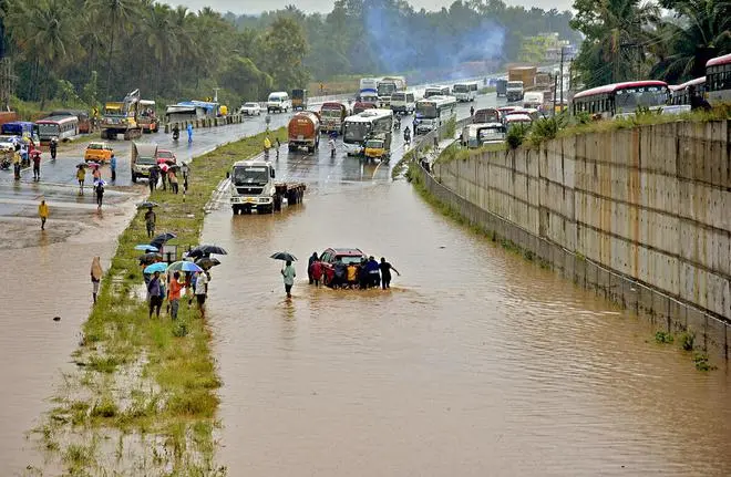
People push a car stuck on the flooded Bengaluru-Mysuru highway following a heavy monsoon downpour at Ramnagar, Karnataka, Monday, August 29, 2022. (PTI)
Isolated very heavy rain
Elsewhere, fairly widespread to widespread rainfall with isolated heavy falls, thunderstorms, and lightning is forecast over West Madhya Pradesh on Monday; East Madhya Pradesh on both Monday and Tuesday; Odisha, from Tuesday to Friday; Marathwada on Monday, Wednesday, Thursday, and Friday; Konkan, Goa, Madhya Maharashtra, East Gujarat and Vidarbha on Thursday and Friday; Jharkhand and plains of Gangetic West Bengal on Friday; and over Chhattisgarh during next five days from Tuesday. Isolated very heavy rainfall is likely over Konkan, Goa, Madhya Maharashtra, Odisha, Vidarbha, and Chhattisgarh on Friday.
North-West and North-East
Fairly widespread to widespread rainfall with isolated heavy falls, thunderstorms, and lightning is forecast over Arunachal Pradesh, Assam, and Meghalaya until Friday. Towards the other side of the country, fairly widespread to widespread light/moderate rainfall with isolated heavy falls, thunderstorms, and lightning were predicted for Jammu & Kashmir and Himachal Pradesh on Monday and over Uttarakhand on Friday.


Comments
Comments have to be in English, and in full sentences. They cannot be abusive or personal. Please abide by our community guidelines for posting your comments.
We have migrated to a new commenting platform. If you are already a registered user of TheHindu Businessline and logged in, you may continue to engage with our articles. If you do not have an account please register and login to post comments. Users can access their older comments by logging into their accounts on Vuukle.