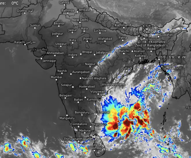
Heavy rainfall is forecast at isolated places over south coastal Tamil Nadu on Sunday and Monday and over south Kerala on Monday as the well-marked low-pressure area over South-West and adjoining South-East Bay of Bengal intensified into a depression on Thursday.
India Meteorological Department (IMD) located the depression to 400 km East-north-east of Trincomalee (Sri Lanka); 550 km east-south-East of Nagappattinam and 630 km south-east of Chennai. It will continue to move to the North-West (towards South Tamil Nadu) until Friday and gradually recurve towards the Comorin across Sri Lanka during the subsequent two days.
Moderate rain or thundershowers continued to be reported on Wednesday from parts of the Andaman and Nicobar Islands and isolated places over Tamil Nadu and Coastal Andhra Pradesh. Centres recording rainfall (in cm) until Thursday morning are Thalaignayer-5; Tirupoondi, Velankanni and Vedaranyam-4 each; Tiruvadanai, Kodiayakarai and Peravurani-2 each.
Outlook for three days from Tuesday (December 27) said scattered to fairly widespread light/moderate rainfall is likely over Tamil Nadu and Kerala while it will be isolated to scattered light/moderate rainfall over coastal Andhra Pradesh, Rayalaseema, Karnataka and the Andaman and Nicobar and Lakshadweep Islands to both sides of the South Peninsula.
Last organised spell
This will likely be the last organised rainfall activity of the year since no other sea-based weather system (low-pressure areas or depressions) is being forecast for the remaining few days. The US National Centres for Environmental Prediction sees light rainfall along the Tamil Nadu coast during the first week of the New Year (2023) as most of the heavier rain heads towards Sri Lanka.
Meanwhile, visibility was reduced to nil at Bhatinda in Punjab on Thursday morning as cold and dry winds continued to fan in from the Himalayas, condensing moisture left behind by a passing western disturbance. Visibility improved from 25 to 200 metres depending on the distance from the lofty reaches of the Himalayas, the IMD said.
Peak fog season
The peak fog season has descended over north-west India from mid-December and will last into early January. Intensity varies with the arrival and passing phases of warm and moisture-laden western disturbances, which are also the only rain-generating weather systems during the rabi crop season. Intervals between two disturbances bring cold from from across the border.
On Thursday, a western disturbance had crossed into north-west India with its warm and moist south-westerly winds mopping up incremental moisture from the North Arabian Sea. They ran into dry and cold northerly to north-westerly mountain winds over the adjoining plains. The movement of the disturbance to the East will gradually help reduce the fog intensity, going forward.
Dense fog may persist
The IMD said dense fog will prevail at isolated pockets over Punjab, Haryana and Chandigarh for next 4-5 days and over Uttar Pradesh for next two days. A similar weather pattern will unfold also over Himachal Pradesh, Uttarakhand and North Rajasthan as well as to the East over Bihar, hills of West Bengal, Sikkim, South Assam, Manipur and Tripura until Friday.
According to the numerical model predictions, the next western disturbance of some consequence may arrive towards the year-end to bring snowfall over the hills and rain or thundershowers in the plains of North-West India. Till that happens, it is likely the region may slip into another cold spell.

A train runs through dense fog during a cold winter morning, in Patna, Thursday, Dec. 22, 2022. | Photo Credit: PTI
Depression in making


Comments
Comments have to be in English, and in full sentences. They cannot be abusive or personal. Please abide by our community guidelines for posting your comments.
We have migrated to a new commenting platform. If you are already a registered user of TheHindu Businessline and logged in, you may continue to engage with our articles. If you do not have an account please register and login to post comments. Users can access their older comments by logging into their accounts on Vuukle.