
A rain-bearing easterly wave with clouds and thunderstorms (in green and purple) struck Sri Lanka coast on Monday, with a tail extending into the Andaman & Nicobar Islands. The wave is expected to hit southern Tamil Nadu next. | Photo Credit: www.meteologix.com/in
A rain-laden easterly wave has arrived ashore on Monday over the Sri Lankan coast, walloping the island nation with moderate to heavy showers.
The wave had hit Andaman and Nicobar Islands the previous day, and India Meteorological Department (IMD) has said the islands will continue to receive scattered to fairly widespread light to moderate rainfall for rest of the week.
Rain bands are expected to strike the south Tamil Nadu coast next, as satellite pictures indicated on Monday afternoon. Isolated heavy to very heavy rainfall is forecast over south Tamil Nadu on Tuesday and heavy rainfall over the larger meteorological subdivision of Tamil Nadu, Puducherry and Karaikal as well as adjoining Kerala and Mahe on Tuesday and Wednesday.
Meanwhile, the IMD has warned that before the western disturbance brings calmer weather to North-West, East, and North-East India, a heat wave will hit: Gujarat (Monday to Wednesday), south-west Rajasthan (Tuesday and Wednesday), Vidarbha (Tuesday to Thursday) and Odisha (Thursday and Friday).
Tamil Nadu and Kerala are proximate beneficiaries of an easterly wave that travels along a straight towards mainly Sri Lanka. The wave is fleet-footed, and rarely waits to unload its moisture upfront unless slowed down through initiation of a cyclonic circulation or low-pressure area. A well-endowed wave with right attributes can even spin up a depression/cyclone.
Scattered to fairly widespread light to moderate rainfall, thunderstorms and lightning are likely over Tamil Nadu, Puducherry and Karaikal for three days from Monday, and neighbouring Kerala, Mahe and Lakshadweep from Tuesday to Thursday. South Interior Karnataka that lies off-tangent may receive isolated light to moderate rainfall, thunderstorms and lightning.

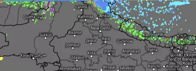
An incoming western disturbance had set rainfall and snowfall (in blue and purple) over the hills of West Himalayas in North-West India after a tryst with the neighbouring north Pakistan and east Afghanistan. | Photo Credit: www.meteologix.com/in
Towards East and North-East India, a cyclonic circulation has been swinging like a pendulum over Assam and Bangladesh for past few days. On Monday, it was located over central Assam, fanning in moisture-laden winds from the Bay of Bengal to trigger rain, thunderstorms and lightning. Seasonal thunderstorms (Kal Baisakhi) appear to be entrenching itself over the region. Incoming western disturbances from North-West India would only add fuel to the proceedings.
The IMD has forecast heavy rainfall over Arunachal Pradesh during for four days from Tuesday; and over Assam and Meghalaya on Wednesday and Thursday. Ongoing isolated light to moderate rainfall/snowfall over Arunachal Pradesh may escalate to being scattered to fairly widespread light/moderate, accompanied with thunderstorms, lightning and gusty winds (30-40 km/hr) over Assam, Meghalaya, Nagaland, Manipur, Mizoram and Tripura for four days from Tuesday.
Winds may pick up speed to 40-50 km/hr over Assam and Meghalaya on Wednesday; and with thunderstorms and lightning over Arunachal Pradesh, hills of West Bengal and Sikkim for three days, on the back of incoming western disturbances.
Published on March 10, 2025

Comments
Comments have to be in English, and in full sentences. They cannot be abusive or personal. Please abide by our community guidelines for posting your comments.
We have migrated to a new commenting platform. If you are already a registered user of TheHindu Businessline and logged in, you may continue to engage with our articles. If you do not have an account please register and login to post comments. Users can access their older comments by logging into their accounts on Vuukle.