
European Centre for Medium-Range Weather Forecasts (ECWMF) sees heaviest rain over East Madhya Pradesh, Vidarbha and Chhattisgarh during this week in the face of active monsoon conditions during this week. | Photo Credit: www.tropicaltidbits.com
Parts of Central India and North-West India have been witnessing heavy to very heavy rain during the 24 hours ending on Monday with Odisha, Jharkhand, Bihar, West Uttar Pradesh, Uttarakhand, Himachal Pradesh and West Madhya Pradesh being battered the most on the second day after the monsoon covered the entire country nine days ahead of the normal date.
Heavy rain also lashed Assam and Meghalaya; Nagaland, Manipur, Mizoram and Tripura; plains of West Bengal; East Uttar Pradesh; Haryana-Chandigarh-Delhi; West Rajasthan; East Rajasthan; East Madhya Pradesh; eastern Gujarat Region; Vidarbha; and Chhattisgarh ensuring most northern half of the country recording normal to above normal rainfall overnight on Monday.
North-West India as well as East and Central India may continue to receive the heaviest of rainfall during the next two to three days till such as a causative low-pressure area located over plains of West Bengal on Monday afternoon sustains itself. It may merge with the monsoon trough later, only to re-emerge over West Uttar Pradesh towards the end of this week.

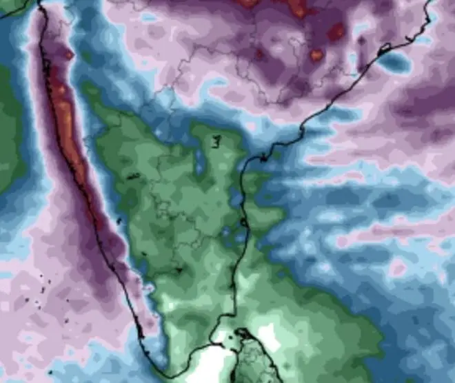
The ECMWF also signals heavy rainfall for West Coast, except south Kerala and Peninsular India, with deficit regions of Telangana, Rayalaseema and Coastal Andhra Pradesh likely not getting major relief during this week. | Photo Credit: www.tropicaltidbits.com
This will ensure that the monsoon trough, backbone of the seasonal rainfall system, holds up over the region hosting moist monsoon easterlies from the Bay of Bengal. The CFS Forecast System model expects conditions favourable for the current spell of the monsoon to be active over the northern half of the country for at least until July 20, according to latest update.
The European Centre for Medium-Range Weather Forecasts (ECMWF) mostly concurs with this outlook for the immediate term (next seven days), indicating only Rajasthan and adjoining Punjab; entire Gujarat; and Peninsular India may sit out of the heavier rain spell. It said almost entire West Coast, especially Konkan and Goa, is likely to make maximum gains during the week.
India Meteorological Department (IMD) said the monsoon trough passed through Sri Ganganagar, Delhi, Fatehgarh, Sidhi, Jamshedpur and centre of the low-pressure area over coastal West Bengal before bending southeastwards and dipping into north-east Bay. This provides for perfect alignment for the trough, and opens window for future low-pressure areas as well.
Providing support are a cyclonic circulation over south Rajasthan and adjoining north Gujarat persists and a secondary east-west trough (other than the monsoon trough, and suggestive of active monsoon conditions) from south-west Uttar Pradesh to the ‘low’ pressure area over coastal West Bengal across south-east Uttar Pradesh and Jharkhand, the IMD indicated.
The ‘low’ over coastal West Bengal will trace out the monsoon trough as it moves slowly along a typical north-west track along the core monsoon region, delivering flooding rain to parts of the region, especially Chhattisgarh; east Madhya Pradesh; and Vidarbha. Parts of this region had logged significant rainfall deficits so far during the monsoon, per IMD statistics.
Published on June 30, 2025

Comments
Comments have to be in English, and in full sentences. They cannot be abusive or personal. Please abide by our community guidelines for posting your comments.
We have migrated to a new commenting platform. If you are already a registered user of TheHindu Businessline and logged in, you may continue to engage with our articles. If you do not have an account please register and login to post comments. Users can access their older comments by logging into their accounts on Vuukle.