

Central, West and South India will continue to be devoid of any major rain activity for another week even as the rain surplus for the country as a whole evaporated entirely on Wednesday under the influence of an ongoing dry spell. The moisture-laden monsoon trough has shifted to the northern half of the country confining rain to parts of East and North-East and North-West India.
‘Low’ may end dry phase
Any change in weather for rest of the country will have to wait for next seven days as a ‘break-monsoon’ phase, when rains shut out over large parts of the country after a long rally, entrenched itself. Numerical model predictions by India Meteorological Department (IMD) hinted at the possibility of formation of a low-pressure area over the Head Bay of Bengal around August 15. But this location would at best serve the cause of East and North-East India and parts of North-West India.
Hope for East-Central India?
A few global models have suggested that this ‘low’ may also break open a helpful trough along the East Coast of India likely bringing some rain into parts of East-Central India from August 19 and lasting for a week over Odisha, Chhattisgarh, east Madhya Pradesh, Jharkhand and Bihar. But this would depend upon the longevity and strength of the underlying trough or circulation over the Bay.
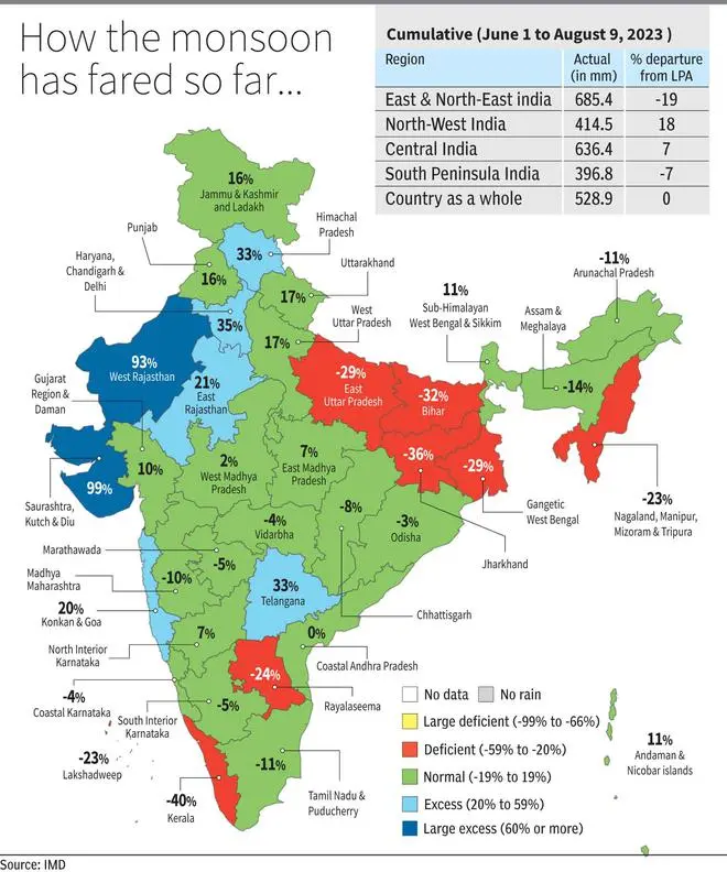
Kerala has worst deficit
On Wednesday, Kerala featured the worst deficit (-40 per cent) among all Met subdivisions after East and North-East India slightly improved the situation following gains from the nearby monsoon trough. Jharkhand (-36 per cent) and Bihar (-32 per cent) are the only two sub-divisions with a deficit of over 30 per cent. East and North-East India may further improve the situation, while individual surpluses may erode and deficits get amplified elsewhere (especially Kerala, Rayalaseema and Lakshadweep).
Western disturbance
Apart from the monsoon trough, what might help the northern parts of the country is arrival of an active western disturbance. The IMD has predicted moderate scattered to fairly widespread rain with isolated heavy to very heavy rain for the hills of North-West India, especially over Uttarakhand, for next four days. It will be isolated heavy over Himachal Pradesh, Punjab, and Haryana on Thursday and Sunday; over west Uttar Pradesh on Sunday; and over east Uttar Pradesh on Thursday and Sunday.
Rain for East, North-East
Over East India, moderate to fairly widespread to widespread rain with isolated heavy rain is likely over Bihar, hills of West Bengal, and Sikkim until Sunday; and over Jharkhand on Saturday and Sunday. It will be isolated very heavy over Bihar on Sunday; and over Sikkim on Saturday and Sunday. As for North-East India, moderate to fairly widespread to widespread rain with isolated heavy to very heavy rain is likely over Arunachal Pradesh ,Assam, Meghalaya, Nagaland, Manipur, Mizoram & Tripura for next fiver days.
![]() Comments
Comments


Comments
Comments have to be in English, and in full sentences. They cannot be abusive or personal. Please abide by our community guidelines for posting your comments.
We have migrated to a new commenting platform. If you are already a registered user of TheHindu Businessline and logged in, you may continue to engage with our articles. If you do not have an account please register and login to post comments. Users can access their older comments by logging into their accounts on Vuukle.