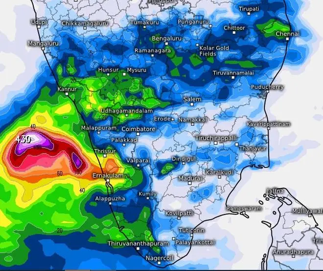
Traditional wet spots in the South Peninsula and the North-Eastern States are getting a sneak preview of what could likely unfold over the next week or so even as the South-West monsoon readies to enter the South Andaman Sea, the Nicobar Islands and adjoining South-East Bay of Bengal.
Normally, the Bay arm of the monsoon lands first, followed by a few days to a week over Kerala over the mainland. India Meteorollogical Department (IMD) has already predicted an early onset over both the Bay (around May 15) and over Kerala on May 27. Private forecaster Skymet Weather expects the onset over Kerala a day earlier.
Heavy to very heavy rain
The 24 hours ending on Sunday morning saw pre-monsoon showers wallop North-East India and Kerala. Isolated heavy to very heavy rainfall with extremely heavy falls were reported from Assam and Meghalaya; heavy to very heavy from Kerala and along the hills of West Bengal while it was heavy over Arunachal Pradesh, Tripura, plains of West Bengal, Lakshadweep and Rayalaseema. Rain or thundershowers also lashed Arunachal Pradesh, Andaman & Nicobar Islands, Lakshadweep, Nagaland, Manipur, Mizoram, Tripura, Tamil Nadu, Puducherry, Jharkhand, East Madhya Pradesh, Chhattisgarh and Interior Karnataka.

Heavy rain is forecast for most of Kerala, parts of South Interior Karnataka and Tamil Nadu into Monday, an India Meteorological Department forecast says. | Photo Credit: (nil)
Even more rain forecast
Chief amounts of rainfall (above 10 cm) during this period are: Jowai-29; Mawkyrwat-26; Cherrapunji-22; Khliehriat-21; Kodungallur-20; Matunga and Aluva-19 each; Tamulpur, Baksa and Mawphlang-18 each; Irinjalakuda-17; Bahalpur and Kochi-16 each; Kokrajhar, Ernakulam and Alappuzha–15 each; Cooch behar-14; Varkala and Pundibari-13 each; Majbat, Goibargaon and Perumbavur-12; Mancompu, Punalur and Thiruvananthapuram-12 each; Mavelikkara and Kumarakom-11 each ;Chalakudy, Cherthala, Tamenglongi and Itanagar-10 each. Forecast for the next few days also spoke about the possibility of the same weather pattern to persist over these areas even as a transiting western disturbance will cool the air over North-West India, keeping heat wave conditions at bay.
Helpful weather features
A cyclonic circulation (remnant of erstwhile cyclone Asani) lies over South interior Karnataka and is expected to hang over the area for the next five days anchoring rain-bearing flows from both the Arabian Sea and the adjoining Bay. It will bring fairly widespread to light to moderate rain with isolated heavy falls over the ghat areas of Tamil Nadu and Coastal and South Interior Karnataka during next five days. Isolated heavy to very heavy falls are likely over Coastal and South Interior Karnataka on Wednesday and Thursday.
Heat wave to abate
Widespread light to moderate rainfall with heavy to very heavy rainfall and extremely heavy falls may continue to lash Kerala and Mahe on Monday while it will be isolated heavy to very heavy falls from Tuesday to Thursday. The western disturbance will trigger scattered to fairly widespread light to moderate rain over Jammu & Kashmir, Himachal Pradesh and Uttarakhand until Wednesday. Isolated hailstorms may be set off over Himachal Pradesh on Monday and Tuesday and dust storms over Punjab, Haryana and Rajasthan.
Prevailing heat wave in most or many parts over Rajasthan with severe heat wave conditions in some parts may reduce in intensity and spread from Monday. Similar conditions over Punjab, Haryana and Delhi will abate on Monday and get confined to South Uttar Pradesh on Monday. Hot conditions over North-West Madhya Pradesh, East Madhya Pradesh and Vidarbha too are expected to relent over the next couple of days.


Comments
Comments have to be in English, and in full sentences. They cannot be abusive or personal. Please abide by our community guidelines for posting your comments.
We have migrated to a new commenting platform. If you are already a registered user of TheHindu Businessline and logged in, you may continue to engage with our articles. If you do not have an account please register and login to post comments. Users can access their older comments by logging into their accounts on Vuukle.