
An El Nino has been declared in the east and equatorial tropical Pacific, proving right forecasts put out by a number of weather and climate models worldwide.
The Australian Bureau of Meteorology officially raised its tracker to ‘El Nino’ status on Tuesday from El Nino ‘watch’ and El Nino ‘alert’ over the past few months.
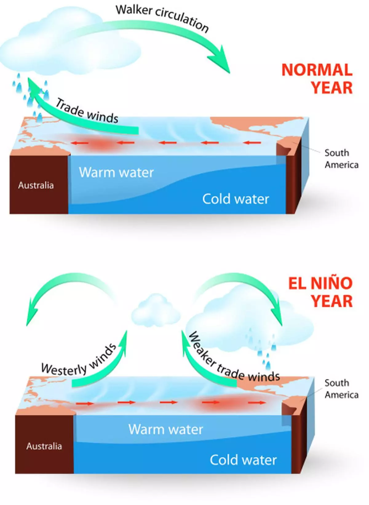
El Nino refers to the abnormal warming of the equatorial and east Pacific that takes away the storminess, cloud-building and rain away from Asia.
The last El Nino was from 2009 to 2010 and the Pacific has either been in its cooler state called La Nina, or neutral since then. The pattern can crimp the hurricane season in the Atlantic, bring more rain across the southern US and warm some northern states.
"It's come on quickly and all of our model guidance predicts it's going to continue to strengthen," David Jones, manager of climate monitoring and prediction at the bureau, was quoted as saying over phone by Bloomberg.
"A significant or substantial event is likely... We look at about 10 climate models and they agree entirely," said Jones from the Australian weather bureau. "We know that once an El Nino events established, its very likely to last through to the end of the year," he said.
IMD forecastSince the Indian monsoon that sets around June is a parallel event, meteorologists have mounted a watch as to how warming of the Pacific could affect the annual rainy season here.
The India Met Department has said in its first long-term forecast that the monsoon could take a beating from the El Nino and deliver less than normal rains this time round.
There is no direct cause-impact relationship linking the two, a fact underscored in 1997 when the monsoon was spared from what was billed as the century’s strongest El Nino.
That year, a positive Indian Ocean Dipole (that mimics El Nino-La Nina in the Indian Ocean) had bailed out the monsoon. Interestingly, there are initial indications that the Indian Ocean could just be churning in this manner this time round, too.
Indian Ocean dipoleAn assessment by the US Climate Prediction Centre had to say this: “slow eastward propagation of an envelope of enhanced convection was observed over the eastern Indian Ocean since the beginning of April. This feature is considerably slower than canonical MJO (Madden-Julian Oscillation wave), and is potentially related to a transition of the Indian Ocean Dipole from negative to positive.”
In a positive dipole scenario, the western part of the Indian Ocean warms up relative to the east, which is helpful for a concurrent Indian monsoon.
Meanwhile, international models suggest that the tropical Pacific Ocean and the atmosphere are reinforcing each other, indicating that El Nino is likely to persist in the coming months.
Sea surface temperatures here are likely to remain above El Nino thresholds through the summer and into the autumn, these models suggested.
An El Nino phenomenon can affect the production of oil palm in Malaysia and Indonesia. The forecast had an immediate impact on Bursa Malaysia Derivatives Exchange where crude palm oil rose to a five-week high, gaining 1.6 per cent.
But more rain in the American continent means another year of surplus grain production, besides higher soyabean output. Reports of higher planting of these crops in the US isn't helping their cause either.
Pre-monsoon ‘low’Back home, an upper cyclonic circulation doing the rounds over south-west Bay of Bengal has got displaced west to south-east Arabian Sea.
It is now forecast to descend to the lower levels of the atmosphere and form a low-pressure area, the eagerly awaited pre-monsoon ‘low,’ over the next two days.
But there are differing views on the track it might take for further journey; some models see it moving north grazing the West Coast and heading for the Gujarat coast in due course.
This would be followed by a burst of rain over peninsula progressing north along the rest of the West Coast and culminating over Gujarat coast. Other models suggest the system crossing the peninsula and heading North-East along the East Coast towards Odisha and Gangetic West Bengal.
![]() Comments
Comments


Comments
Comments have to be in English, and in full sentences. They cannot be abusive or personal. Please abide by our community guidelines for posting your comments.
We have migrated to a new commenting platform. If you are already a registered user of TheHindu Businessline and logged in, you may continue to engage with our articles. If you do not have an account please register and login to post comments. Users can access their older comments by logging into their accounts on Vuukle.