The 2022 South-West Monsoon may enter the South Andaman Sea and adjoining South-East Bay of Bengal over the next three days (around May 15, Sunday) in the wake of strong cross-equatorial, south-westerly flows triggered by erstwhile severe cyclone ‘Asani.’
India Meteorological Department(IMD) said fairly widespread light to moderate rainfall may lash the Andaman & Nicobar Islands during the next five days. Isolated heavy falls are forecast over the region from Saturday to Monday. Squally weather (wind speeds of 40-50 kmph gusting to 60 kmph) may prevail over the South Andaman Sea on Sunday and Monday, likely marking the monsoon onset.
Onset over Myanmar
This would coincide with the onset over southern Myanmar, though later than the May 8-13 timeline projected earlier by the Myanmar Department of Meteorology and Hydrology. But the onset around May 15 over the Andaman & Nicobar Islands would be earlier by five days to a week.
The next significant pit-stop for the monsoon is Sri Lanka, where it usually reaches by around May 22, and thereafter over Kerala (mainland India) by June 1. Global model predictions as well those suggested by the numerical projections of the IMD, however, go to suggest that both these onset could materialise earlier than usual this year.

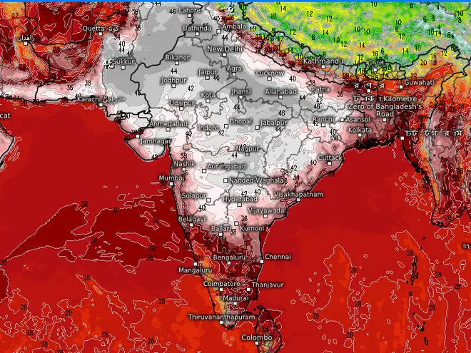
Projections for Sunday also show a heat wave (in ash and silver white colours) building over the entire northern half of the country even as heavy rain keeps the weather cool over the South Peninsula.
Arabian Sea warming
The Arabian Sea is warming up in anticipation to host the other arm of the monsoon, with the warmest pool (30-31 degrees Celsius) on Thursday extending along a swathe from the West Arabian Sea and into waters along the Goa, Karnataka and Kerala coasts. Both these arms execute a pincer-like movement to drag the monsoon to mainland India.
A monsoon-friendly Madden-Julian Oscillation (MJO) wave is expected to transit the region from next week. Meanwhile, erstwhile Bay of Bengal cyclone ‘Asani’ weakened three notches to become a well-marked low-pressure area over Coastal Andhra Pradesh on Thursday, after refusing the forecasters’ bid to recurve over the waters and move away.
Dumps heavy rainfall
The 24 hours ending on Thursday morning saw remnant of Asani dump isolated heavy to very heavy to extremely heavy rainfall over Coastal Andhra Pradesh, Meghalaya; heavy to very heavy over Arunachal Pradesh; and heavy over Rayalaseema, Jharkhand, Sub-Himalayan West Bengal, Sikkim, Bihar, Tripura and Coastal Karnataka.
Maximum amounts of rainfall recorded (above 10 cm) during this period are Kandukur(26), Mawsynram(23), Atmakur(20), Cherrapunji and Bhalukpong(19 each), Khliehriat(18), Haflong and BP Ghat(15 each), Bestavaripeta, Ongole, Kavali and Mawkyrwat(12 each), Cumbum and Racherla(11 each) and Majuli and Gangtok(10 each).
The remnant ‘low’ from Asani will bring light to moderate rainfall at many places with heavy rainfall over Coastal Andhra Pradesh on Friday while it would be heavy to very heavy over Rayalaseema. Fishermen are advised not to venture into these sea areas.


Comments
Comments have to be in English, and in full sentences. They cannot be abusive or personal. Please abide by our community guidelines for posting your comments.
We have migrated to a new commenting platform. If you are already a registered user of TheHindu Businessline and logged in, you may continue to engage with our articles. If you do not have an account please register and login to post comments. Users can access their older comments by logging into their accounts on Vuukle.